


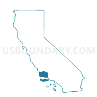
Voting District 10022, Santa Barbara County, California
About
Outline

Summary
| Unique Area Identifier | 543062 |
| Name | Voting District 10022 |
| County | Santa Barbara County |
| State | California |
| Area (square miles) | 5.28 |
| Land Area (square miles) | 5.27 |
| Water Area (square miles) | 0.01 |
| % of Land Area | 99.84 |
| % of Water Area | 0.16 |
| Latitude of the Internal Point | 34.44551310 |
| Longtitude of the Internal Point | -119.58104020 |
Maps


Graphs
Select a template below for downloading or customizing gragh for Voting District 10022, Santa Barbara County, California


Neighbors
Neighoring Voting District (by Name) Neighboring Voting District on the Map
- Voting District 10016, Santa Barbara County, CA
- Voting District 10021, Santa Barbara County, CA
- Voting District 10556, Santa Barbara County, CA
- Voting District 10561, Santa Barbara County, CA
- Voting District 10566, Santa Barbara County, CA
- Voting District OCEAN, Santa Barbara County, CA
Top 10 Neighboring County Subdivision (by Population) Neighboring County Subdivision on the Map
- Santa Barbara CCD, Santa Barbara County, CA (184,449)
- Carpinteria CCD, Santa Barbara County, CA (17,718)
Top 10 Neighboring Place (by Population) Neighboring Place on the Map
Top 10 Neighboring Elementary School District (by Population) Neighboring Elementary School District on the Map
- Montecito Union Elementary School District, CA (6,182)
- College Elementary School District, CA (5,818)
Top 10 Neighboring Secondary School District (by Population) Neighboring Secondary School District on the Map
- Santa Barbara High School District, CA (184,132)
- Santa Ynez Valley Union High School District, CA (21,027)
Top 10 Neighboring Unified School District (by Population) Neighboring Unified School District on the Map
Top 10 Neighboring State Legislative District Lower Chamber (by Population) Neighboring State Legislative District Lower Chamber on the Map
Top 10 Neighboring State Legislative District Upper Chamber (by Population) Neighboring State Legislative District Upper Chamber on the Map
Top 10 Neighboring 111th Congressional District (by Population) Neighboring 111th Congressional District on the Map
Top 10 Neighboring Census Tract (by Population) Neighboring Census Tract on the Map
- Census Tract 17.06, Santa Barbara County, CA (4,693)
- Census Tract 14.02, Santa Barbara County, CA (3,392)
- Census Tract 15, Santa Barbara County, CA (3,091)
- Census Tract 9900, Santa Barbara County, CA (0)